
Imagine having your town to be seen in your game. As fascinating as it sounds, it is now becoming the reality of most games, movies, and even short movies. Saving pictures from a website is easily achievable for anyone. In today's digital landscape, believing that users can be prevented from saving pictures is unrealistic. Yet, few realize this principle extends to 3D objects. If you have a 3D project coming up, you might want to get help from Google Maps for stunning visuals.
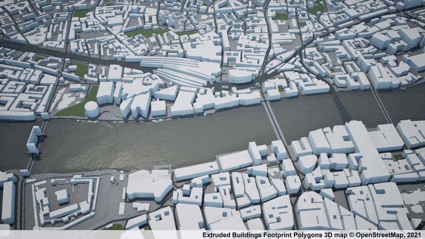
 Photogrammetry 3D city model of London: (AccuCities, CC BY-SA 4.0 <https://creativecommons.org/licenses/by-sa/4.0>, via Wikimedia Commons)
Access and Benefits of Using Google Maps 3D Models
First of all you can have great final results with Rebusfarm cloud rendering services and get a free trial to render your first project with us and improved lighting and texture of your projects. In this article, we will explore Google Maps 3D Model’s benefits and some tips for using maps in a better way. Let’s dive in!
Google Maps 3D models offer a range of benefits and access to exciting new features. With these models, users can enjoy more realistic map visualizations, capturing stunning views of natural features and famous landmarks. The availability of these new features opens up a world of storytelling possibilities, empowering industries like tourism, mobility, media, and science.
The introduction of Photorealistic 3D Tiles enables even more lifelike representations of the world on the map, while a seamless 3D mesh model of the real world, adorned with high-resolution RGB optical imagery, brings a new level of detail. Moreover, the WebGL API introduces the tilt and rotation feature, allowing maps to be viewed from any angle.
Download Google Maps 3D models for offline use
This API, which utilizes the same 3D map source as Google Earth, also enables 3D route guidance within Google Maps. Regrettably, downloading Google Maps 3D models for offline usage is not currently feasible. However, it is worth considering alternative approaches. One possibility involves employing 3D modeling software such as Blender and RebusFarm to convert Google Maps images into 3D models. Another option is to utilize Google Earth, which permits users to download maps for offline access.
Currently, this functionality is limited to 2D maps and does not encompass 3D models. Additionally, instructional videos on YouTube provide guidance on exporting 3D photogrammetry meshes from Google Maps. But if you are interested, we shared a handy tip on how to download the 3D models used in Google Maps & Google Earth so that you can use them in your scenes. It's a tip identical to aerial views, as for close-up shots, you probably need to tweak the models a lot!
Google Maps API: Collection of 3D models
The Google Maps JavaScript API allows developers to embed interactive maps, add markers and overlays, and incorporate Street View imagery. While the API offers access to map-related data and functionality, it does not specifically provide a built-in collection of 3D models.
 Render of Isle of Dogs London 3D Model.AccuCities, CC BY-SA 4.0 <https://creativecommons.org/licenses/by-sa/4.0>, via Wikimedia Commons
Google Earth Pro: Real-world locations
Google Earth Pro offers a detailed 3D exploration of real-world locations, separate from Google Maps. It allows users to view high-resolution satellite imagery, 3D buildings, and terrain information.
Google Earth Pro includes features such as historical imagery, measurement tools, and the ability to create custom tours or presentations. It provides a more comprehensive and in-depth experience for exploring Earth's geography compared to the standard Google Maps interface.
Users can navigate to specific locations, search for landmarks, and visualize the Earth's surface in 3D using Google Earth Pro. This desktop application is currently available for Windows and macOS, providing additional functionality beyond what is offered in the Google Maps web or mobile applications.
Models are created using advanced techniques
In various fields and industries, models are indeed created using advanced techniques to capture and represent real-world objects or environments. These techniques aim to enhance the models' accuracy, detail, and realism, providing valuable insights and information for various applications. Three such techniques that are commonly used are photogrammetry, laser scanning, and satellite imagery.
Photogrammetry
Photogrammetry extracts 3D data and measurements from overlapping photographs or images. By analyzing the differences in perspective and appearance of the objects or features captured in the images, photogrammetry algorithms can reconstruct their 3D shape and position accurately.
This technique is widely used in architecture, archaeology, geography, and virtual reality to create detailed 3D models of real-world objects or landscapes. Check this out for more information about photogrammetry.
Laser scanning
Laser scanning, also known as LiDAR - Light Detection and Ranging, is a technique that uses laser beams to gauge distances and create precise 3D representations of objects or environments. In laser scanning, a laser scanner device emits laser pulses that bounce back when they hit a surface.
By measuring the time it generally takes for the laser pulses to return, along with other parameters like the angle and intensity of the reflected laser beams, highly accurate 3D models can be generated. Laser scanning is commonly used in applications such as surveying, engineering, urban planning, and environmental monitoring. You can use the RealityScan app, anyone can create 3D models in just a few minutes by following a few simple steps. It's available for IOS and it's free.
Satellite imagery
Satellite imagery involves capturing images of the Earth's surface using satellites orbiting in space. These satellites are equipped with various sensors, including optical sensors and synthetic aperture radar (SAR), which collect data about the Earth's surface from different wavelengths of electromagnetic radiation. By analyzing the captured imagery, researchers and analysts can generate detailed maps, models, and other geospatial data. Satellite imagery is extensively used in fields like cartography, environmental monitoring, agriculture, disaster management, and urban planning.
Tips for Optimizing the Use of Google Maps 3D Models
Google Maps provides 3D models for various locations around the world, allowing users to explore and navigate virtual environments. To optimize the use of Google Maps 3D models, here are some tips:
Improve performance and load times
To enhance Google Maps 3D models and improve the performance and load times of your projects, you should do the following:
- Simplify geometry and use level-of-detail (LOD) models.
- Optimize textures with compressed or lower-resolution versions.
- Streamline asset loading for faster performance and an improved user experience.
Lighting and shadows play a crucial role
To improve lighting and shadows in 3D models for your project, you should consider these tips:
- Consider light sources for realistic and immersive scenes.
- Use shadows effectively for added depth and realism.
- Optimize lighting calculations to enhance performance.
Combine 3D assets with an excellent render farm
To improve rendering efficiency by combining 3D assets with a render farm such as Rebusfarm, remember that we support all main 3D software to render. Please select your 3D software or renderer and you should consider the next three tips:
- Utilize a render farm for faster rendering of complex scenes or large-scale projects.
- Batch renders multiple 3D assets together to optimize the rendering process.
- Optimize rendering settings, adjusting parameters for image quality, anti-aliasing, and ray tracing to balance visual quality and rendering times.
Conclusion
Incorporating Google Maps 3D models can significantly enhance your 3D project. By leveraging simplified geometry, optimized textures, and streamlined asset loading, you can improve performance and user experience.
Additionally, considering light sources and shadows and optimizing rendering settings can elevate the visual quality and realism of your project. With these enhancements, render farm abilities and Google Maps 3D models become valuable assets for creating immersive and visually impressive 3D experiences.

About the author
Nicole Holt is an experienced 3D enthusiast with a career in marketing and content writing. Thanks to this unique combination, she is able to showcase the technical intricacies of 3D art and rendering while also making the subject accessible to a wide audience. When she's not immersed in the digital world, Nicole can be found in the great outdoors, most likely with her beloved dog, Sammy.